Sunday, April 12, 2020

Rarotonga in the Cook Islands


Rarotonga – The Cook Islands

In April of 2019, Elaine, Anne, myself and our New Zealand friends Liz, Dennis and Emily O’Callaghan enjoyed a week on the Island of Rarotonga in the Cook Islands.  Most people that I have told that we were on Rarotonga had the immediate question of Raro what? 

The Cook Islands  were first sighted in 1813 and later named after the great explorer James Cook.  A self-governing territory of New Zealand, the Cook Islands are made up of 15 inhabited islands in the South Pacific, lying about 2,000 miles northeast of the northern tip of New Zealand.  The map-area that the country covers is about the size of India; however, most of that consists of the waters of the Pacific Ocean.  The total land-area is about 91 square miles – not very big.  The largest of the 15 islands is Rarotonga (24 square miles).  Here is a model of the Island:


The nation has a population of about 14,000, 9,000 of whom live on Rarotonga.  Since New Zealand has a very close relation with the Cooks, the islanders can live and work in New Zealand without any passports, as they have all the rights of a New Zealand citizen.  As employment opportunities are limited in the Cook Islands, over 60,000 of them now live and work in New Zealand.  Many years ago, when we lived in NZ, there were a large number of Cook Islanders who attended the same church that we did.  We met several of them.


The Cook Islanders are Cook Island Maori, a Polynesian group very closely related to the Maori of New Zealand.  The language is similar and can be pretty much understood to the NZ Maori, and vice versa.

As you can see from the model above, this is a volcanic island, as are most of the southern islands.  As you move north, the islands are coral atolls.  Rarotonga has a coral reef that nearly surrounds the island.  Inside the reef is a large lagoon which creates a vast calm area in which one can swim, snorkel or scuba dive.


We spent a few days snorkeling in the water.  The darker spots in the water in the photos are volcanic rock, often covered in beautiful coral and abundant multicolored fish.  In the one photo, you can see the large area of the reef.  It is about half a mile or more to the reef in this area.  The reef does come closer to shore in some places.  The first photo was taken from our rented home.  The reef here was maybe a quarter mile from shore.

Dennis (NZ friend) arranged the accommodations for the six of us.  It was a 3 bedroom villa, right on the seashore.  It was fully-furnished and had modern facilities.


There are international flights from USA and NZ on Air New Zealand to Rarotonga.  To get to the other islands there are interisland flights on smaller planes.  As the weather is warm year-round, one gets off and on the planes on the tarmac.


The capitol of the Cook Islands is Avarua, a small town on Rarotonga.  Each Saturday, there is a market day.  Locals sell their creations at the fair.  Baskets, carvings, foods, clothing etc.  The specialty is the locally obtained black pearl.  The local people also perform native dances, something like the Hawaiian hula, but at a much faster pace.


If you are a fan of franchised fast food outlets (Burger King, etc.) and hotel chains (Sheraton, etc.), the Cook Islands is not a place for you.  Hotels are locally owned, as are the restaurants.  An attempt to bring in a Sheraton had the following results:

The Sheraton Rarotonga was a mostly-constructed yet never-opened resort situated in the Cook Islands. The project could best be described as a PPP or Private Public Partnership that was backed primarily by local government finances while the Sheraton agreed to serve as the property managers. This time, there’s no story of haunting or inauspicious omens. Rumor has it that local mafia members looted the $36 million development fund. The government ran out of money, and construction was halted at 80% completion.

We drove by the structure.  Now a big, decaying concrete structure, covered partially by the encroaching jungle. 


Getting around the island is easy, as a paved road encircles the island with the ocean on one side and the jungle and housing on the other.  There is a bus that comes along in either direction every hour; or you can use the local popular motor bike (for rent); or rent a car.  We used the bus for a few days and then rented a car.


The fauna consists mainly of wild pigs (Anne saw some on her cross-island hike), chickens and ubiquitous dogs.  The dogs have intensively interbred over the years and one can observe some strange genetic mutations.  I saw one dog that had extra paws growing out of its upper legs.  Dogs are everywhere and they mostly look alike.  As a non-lover of dogs, I saw this as the only negative thing about Rarotonga.  The ones wearing a collar belong to someone and the ones that are not wearing a collar are strays.  Well, actually, they all are roaming around.  Some have taken to the ocean and swim out to a rock and just watch the fish swim by.  They do not harm or bother anyone and seem to be oblivious to humans.  We were eating outside at one of their food shops, a dog came by our picnic table and just sat there, not begging, just sitting.  We did toss a few pieces of bread to it, which it ate, but did not come by begging for more.


Before the British provided protection of the Cook Islands and Christianized the peoples, there were three main tribes on Rarotonga.  Of course, they could not get along with one another and often warred upon one or both of the other tribes.  Taking prisoners was the occasion for feasting.  The prisoners participated in the feast, as the main course for dinner.  The Brits quickly stamped out cannibalism.  A new problem arose, what do we do with the deceased?  The soil is not deep in most places, with volcanic rock only a few inches underneath the soil.  They chose above ground burials in their own front yards or church cemeteries.  As property stays within the same family, and is not allowed to be sold to non-islanders, you see many generations of deceased monuments in nearly every yard. 


While there, we attempted to learn about their history and culture.  We visited a museum, went to a cultural heritage center, enjoyed the dancers at market days and attended religious services at the Catholic Cathedral on Easter Sunday.

The museum is in a large pole-building and has several well-displayed exhibits.  Polynesians explored and settled much of the south and eastern Pacific, from Tahiti, to Hawaii, to  New Zealand, and the Cook Islands.  One of the ways they navigated from island to island was by using stick charts.  I have no idea how they used them, but this is what they looked like.

A series of panels in the museum briefly explain the various phases of the islands’ history.  I particularly liked this panel, as it shows a couple of their early postage stamps.   I have many of their stamps in my stamp albums.


There are several tanks which show the colorful reef life that we encountered while snorkeling.  The plants and animals in the tanks are all live.


The carvings of their gods (I think that they are of their fertility gods) are very similar to those that we have seen in Hawaii and New Zealand. 


The cultural heritage center is located on a mountainside within the jungle.  There are no dangerous animals (lions, snakes, crocodiles, etc) which you might meet up with in the jungle or anywhere on the islands.  The heritage center has an indoor component which displays various tools, cooking utensils, etc.

The outside portion is a large area of land which includes a temple and various volcanic stones that were used for different purposes.  This first picture shows the “guilty rocks”.  The story of which is if a person was guilty of violating one of the many taboos, they were executed unless they could carry the rock (the heavier of the two were for the guys and the light for the gals) to the ocean and then back to this place several hundred feet above sea level.  Of course, practically no one would be able to carry a two hundred pound rock on this route.

Compass Rock is said to be a navigation device that could be seen from the ocean and was said to be used for navigation to other islands.  They must have had really good vision.

A demonstration on how to husk a coconut was given, along with a tasting of the fresh milk and meat of the coconut.  If you have ever tried to husk one, you know how difficult it is.

After being guided around the grounds, we were treated to a Polynesian lunch consisting of chicken, plantains, taro and breadfruit all prepared in the traditional way of cooking, an earth oven.  Pretty much like a luau would be in Hawaii or a hangi in New Zealand.  A fire heats the rocks, then food is laid upon the rocks and then covered with banana leaves.

The chicken was delicious, can’t say the same for the other foods, it was bland and tasteless at least to me.  I have had taro before and never had a taste for it.  However, we did get to wash it all down with fruit juices and a fresh fruit platter for dessert.

While up in the jungle, we walked to Wigmore Falls, The Cook Islands highest waterfall.  It is no Niagara.

One day, while Elaine, Dennis and I went snorkeling, Anne decided to do the cross-island hike.  The hike starts at sea level and goes all the way up to Rarotonga’s highest point, the needle.  The hike takes about 4 hours.  Well, that’s for Anne.  For me, I’d still be there.


The two largest western religious denominations are Congregational and Catholic.  The largest Congregational Church is quite old (1800s).  It sits right next to the former royal palace.  The inside is furnished with beautiful wood.

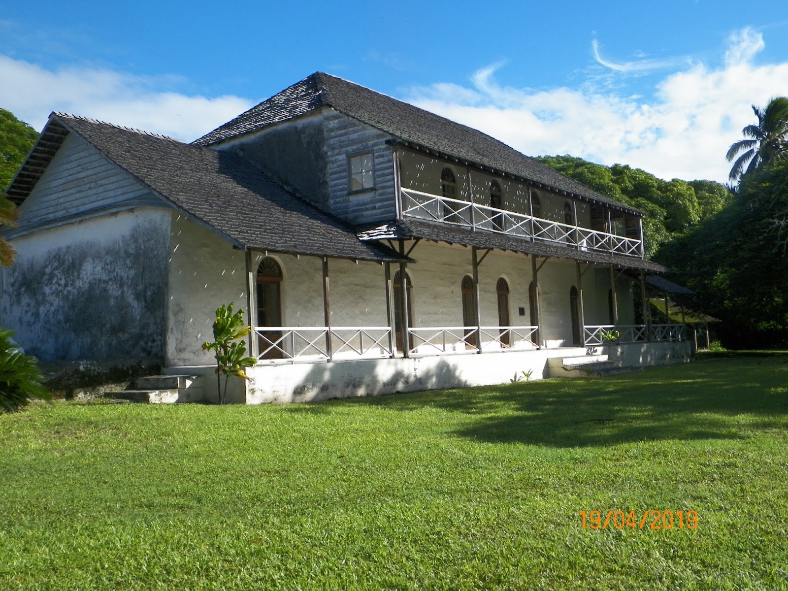
The palace is not fully restored, as funds are lacking.  The building is a large structure with a porch (lanai) surrounding it.  Some of the rooms inside have some restoration and historical photos.


On Easter Sunday we attended St. Joseph’s Cathedral, one of 3 Catholic Churches on Rarotonga.  Instead of bells at consecration, they use a big drum.  Songs are pretty much sung acapella.  The people dress up in all their finery.  For the women, it is a white dress and hat.  The tourists are in shorts and shirts.

A warm welcoming people in the south Pacific, good bye for now, I do hope to return.


Friday, March 31, 2017

Boston sights 2016


Founded in 1630, Boston is one of the oldest cities in the USA.  Boston’s population of 668,000 is the largest of all New England cities, while it is only the 23rd largest city in the USA.  The SMSA (Standard Metropolitan Statistical Area) of Boston has over 4.7 million inhabitants, the 10th largest SMSA in the USA.  As Anne has lived in the Boston SMSA for six years, we find ourselves traveling there for frequent visits.  This slutigram will focus on our visits in June and November of 2016.

Boston and its nearby environs was the site of much of the early activity towards the 13 colonies becoming an independent nation.  In the May 2016 slutigram, I spoke of the Adams’, who were our 2nd and 6th presidents.  In the November 2008 slutigram several famous sites of Boston are included.  I will not be repeating those in this slutigram.  They include the Bunker Hill Monument, Faneuil Hall, the USS Constitution, the site of the Boston Massacre and some other sites.  However, I have found that we had not even begun to take in all the history and culture that Boston has to offer. 

Henry Wadsworth Longfellow wrote of the “Ride of Paul Revere” during the American Revolution.   Revere was 40 years old when the famous ride occurred.  Revere served in the French and Indian war as part of the colonial militia.  After returning to Boston, he took up his father’s trade as a silversmith.  However, due to tightening British restrictions after the war, his business was faltering to such an extent that he took up dentistry.  Not the practice as we know it today, but mainly pulling teeth.  He soon was an active member of the “Sons of Liberty”, a dissident organization.  As the years progressed, he became even more dedicated to the cause of colonial rights.  Revere was one of the organizers of the Boston Tea Party and served as a dispatch rider to New York City and other places for the Committees on Correspondence, another patriotic group.

In 1770, Revere purchased a house in the north side of Boston.  He sold the home around 1800.  Fortunately, the building has survived to this day, mainly due to the efforts of his great grandson who purchased the home in 1902.  The home is open for tours and has many artifacts associated with Paul Revere.


Revere would have been only a footnote to the Revolution if it weren’t for the ride he made on April 18, 1775 to warn Samuel Adams and John Hancock of the dispatch of British troops to Lexington and Concord.   William Dawes also made the ride by a slightly different route.  However, Longfellow did not include Dawes in his poem.


 His ride on a borrowed horse began at the Old North Church, where lanterns were hung to indicate whether the troops were coming by land or by sea.  The church stands today and is open to sightseers.  It is humbling to sit in the pews where many of our early founders worshipped.  The church remains active and has Sunday services.


The British prevented Revere's return to Boston, so he and his family rented a house in Watertown, a few miles upriver.  Revere served as a Lt. Colonel in the army until 1779.  He fought in battles in Massachusetts, Rhode Island and Maine (part of Massachusetts until 1820).

Paul Revere lived to 83 years, a very long and distinguished life in those times.  It seems that I should learn more about his exploits – a trip to the library will be on my agenda.

Since we had seen the old north church, we though balance required a stop at the old south church.


Speaking of churches, in north Boston we walked past St. Stephen’s Church.  Which I initially thought was the old north church.  After seeing old north church, we again passed St. Stephen’s.  A plaque on the Church building drew my interest.  This church was where Rose Fitzgerald was baptized and where her funeral services were held 104 years later.  Rose was the mother of President John Kennedy.


In 1638, John Harvard bequeathed a parcel of land that was to become Harvard Colledge (spelled it that way back then).  He is honored as one of the founders of Harvard University in Cambridge, Mass.  Today, Harvard sprawls across several blocks of Cambridge, making it difficult to know whether you are on campus or not.  We haven’t taken a tour of the campus as yet.  However, we have spent time in a few coffee shops near Harvard Square, where you can rub elbows with Professors, students and even the homeless.  The cafe culture, a true melting pot.


I think it was in 2015, that Harvard’s 3 art museums merged and now is lodged in one building.  As Elaine and I both enjoy art museums; we spent the better part of the day feasting our eyes on works of art spanning the centuries.  Here are a few examples.


Egyptian art:


Sumerian/Assyrian:


Greek:

Roman


Van Gogh's self portrait; he painted it so that his missing ear was not visible.


Famous Americans.  This is a portrait of George Washington by Gilbert Stuart and Benjamin Franklin


There are 6 floors to the museum, with a large open space in the center of the building.


The special visiting exhibit was Aboriginal Art:


On another day, we went to the Isabella Stewart Gardner Museum.  The museum is unlike other art museums, as it is a total work of art from the building to its contents.  Much of the gallery building is a disassembled Venetian Palace that has been incorporated into the gallery.  Unfortunately, we forgot the camera.  I think we will revisit on our next visit to Anne.  For some wonderful reason, admission is waived for veterans and up to 3 others. 


The Massachusetts Historical Society houses some interesting exhibits.  The purpose of the Society is to highlight the state’s important roles in historical events that occurred in the state or nation.  Portraits abound.  In order, here are an early settler of Massachusetts (can‘t remember his name, but he must have been important by the looks of his garb) and Daniel Boone in his elder years.  I do not know what significance that Boone has to Massachusetts.


A pen that signed the Emancipation Proclamation, a copy of Harriet Beecher Stowe’s Uncle Tom’s Cabin, a slave collar and an epaulet that belonged to George Washington.  Pretty neat stuff.


Another day found us at the Massachusetts Institute of Technology’s (MIT) Museum.  MIT is our premier doctoral level engineering university.  The museum unsurprisingly focuses of various aspects of engineering to include robotics and strobe photography.  Harold Edgerton, from Aurora, Nebraska was a beloved professor at MIT who pioneered the use of strobe photography.  The famous stop-action photo of a bullet as it passes through an apple is only one of the many strobe photos one can see at MIT.  Incidentally, there is an Edgerton Museum in Aurora, Nebraska where you can learn about this man’s contributions.


Boston is home to the Christian Science religion and its famous newspaper the Christian Science Monitor.  Headquarters is in downtown Boston.  Inside the Newspaper’s building you can tour the Maparium, a stained glass model of the globe’s various nations in the 1930s.  It is a very large globe.


Time for lunch.  We wished to enjoy dim sim in Boston’s Chinatown, which is several blocks where you get the feeling of being in China.  Lunch was yummy.


While walking along the city’s streets, we encountered some Christmas carolers who were dressed in 19th century fashion. 


Getting around town is pretty easy and inexpensive.  A 7-day transit pass enables you to ride buses, the T (light rail and subway) and several inner harbor ferries all for about $20.25.


Anne comes with us as her schedule allows.  On one outing to Bunker Hill, we had lunch at the Warren Tavern.  You may remember that this is the oldest restaurant in Charlestown and that it was featured in the November 2008 slutigram of our fall foliage tour.  In both photos, we are sitting in the same booth.


 A tour of Boston would be incomplete without a brewery tour, as there are many micro-breweries in Boston.  We haven’t toured the Sam Adams brewery as yet, but we did tour Harpoon Brewery.  A good tour and a good beer.


On our most recent trip, the Boston Public Library had a traveling exhibit which focused on Shakespeare’s works.  There were 2 parts of the exhibit, one on maps and the author and the other on his books.  The books dated from the early 1600s.   For instance, Macbeth is known as the “melancholy Dane” and you may remember the line “something is rotten in the state of Denmark” so a map of Denmark would make sense; so would a map of Venice from “The Merchant of Venice” etc.  There were many map locations that related to the bard.  This was a temporary exhibit, so I believe it is gone.


Anne often finds interesting things to do and see.  Along with Rhia, a friend of Anne’s, we enjoyed a day on the banks of the Charles River in Cambridge watching the Dragon Boat Races. 


Of course, we love our time with Anne and friends and plan frequent returns to Boston.