How do we choose where to take trips. One source was the Walt Disney
Show of 1955-6, which featured a series on the life of Davy Crockett. I was an impressionable 6-year old at that time. Like many others, I had a coonskin
cap and a cork popgun. Davy was my idol
and, in some ways, still is.
The Ballad of Davy Crockett
By Fess Parker (who played the role of Davy)
Born
on a mountain top in Tennessee (actually
born along the banks of a river not on a mountain top)
Greenest state in the land of the free
Raised in the woods so he knew ev'ry tree
Kilt him a be 'are when he was only three (he did kill many bears, but not beginning at age 3)
Davy, Davy Crockett, king of the wild frontier! (No one called him Davy – it was David)
Greenest state in the land of the free
Raised in the woods so he knew ev'ry tree
Kilt him a be 'are when he was only three (he did kill many bears, but not beginning at age 3)
Davy, Davy Crockett, king of the wild frontier! (No one called him Davy – it was David)
.
.
.
Off through the woods
he's a marchin' along (he was on the Natchez Trace)
Makin' up yarns an' a singin' a song
Itchin' fer fightin' an' rightin' a wrong
He's ringy as a be 'are an' twict as strong
Davy, Davy Crockett, the buckskin buccaneer!
Makin' up yarns an' a singin' a song
Itchin' fer fightin' an' rightin' a wrong
He's ringy as a be 'are an' twict as strong
Davy, Davy Crockett, the buckskin buccaneer!
The ballad goes on for
many a verse, extolling Davy’s virtues in an exaggerated or untrue form. One of the episodes of the Disney series
featured a rivalry with the notorious keel-boatman, Mike Fink (see Wikipedia on
Mike). Much of the tale is probably fiction, but it
did impress this 6 year old boy from western Connecticut.
Davy and Mike fought each
other on their respective keel-boats. Keel-boats
transported farm crops, whiskey and livestock down the Ohio and Mississippi
Rivers to markets in Natchez, Mississippi and New Orleans. During the era before steam power, there was
no way to easily barge upriver. The
barges (boats) were disassembled and sold as lumber.

The boatmen and women (if
the Mike Fink legend is correct) would walk back to Tennessee and Kentucky
along a series of woodland trails known as the Natchez Trace.
Besides playing Davy
Crockett, Fess Parker also starred in the TV series Daniel Boone. Age 84, Mr. Parker passed away on March 18,
2010. David Crockett died at the battle
of the Alamo in San Antonio, Texas in March of 1836.

The other source of an idea
for a trip were our friends and past travel companions (fall foliage tour
of 2008 and Lewis and Clark trip of 2014) Jim and Sandy Cooper. Sandy indicated that she wanted to see the Deep
South and some of the historic civil rights places in Alabama and Mississippi.
Following the
Natchez Trace starting from Franklin, Tennessee was to be the spinal column of our
trip. I say spinal column because we
took several side trips far off the historic Trace and extended it to New Orleans.
This will be a long
slutigram and I feel it is better
to organize the trip into categories rather than chronologically as they
occurred in history or even as we encountered them. The categories will be: 1. The Natchez Trace. 2.
Native American history. 3. Military historic sites on and near to the Trace. 4.
Civil Rights. 5. New Orleans.
6. Other interesting places. Several photos have text from signs. I recommend that you click on the photo to enlarge it to make reading easier.
1. The Natchez Trace.
The Natchez Trace is one
of many trails that provided a path through the trans-Appalachian forest. It is believed that many of these paths
followed those originally made by bison, elk and other large mammals. These paths were later used by the indigenous
Native Americans for hunting purposes.
As we found, evidence exists for very ancient human settlement along the Trace.
When the colonists first
crossed the Appalachian Mountains, it was often easier to travel by boat down
the Mississippi and then sail to the east coast colonies than to go over the
mountains. This was the era before the
use of steam power on the riverboats and before roadways into the wilderness.
The Trace winds its way
through 444 miles of forest from south central Tennessee, central Alabama
and western Mississippi, ending at Natchez, Mississippi. In 1801,
President Thomas Jefferson designated the Trace a national post road
for mail delivery from Nashville to Natchez.
In 1938 the Natchez Trace Parkway became a unit of the National Park
Service and the road was finally completed in 2005.
We followed the Trace
from north to south at the leisurely 50 miles per hour speed limit on a
well-maintained paved road beginning at Pasquo, Tenn. The scenery varied only slightly during the
first 200 or so miles. Large old trees
on both sides of the road was the normal view, with occasional points of
interest.

Our first stop was a
Birdsong Hollow where we appreciated the architectural beauty of the Double
Arch Bridge.


After 30 miles on the Trace
we exited and drove the short distance to the town of Clifton, Tenn. To see the
home of that well-known 11th President of the USA, James K. Polk.


Other than the White
House, this is the only remaining home in which Polk lived. When you read of his accomplishments as
President, you wonder why he seems to be ignored in so many histories of the
early USA. Read the text of this photo
(probably will have to enlarge it by double clicking on it) to learn that he was the
only president to accomplish all of his campaign promises.

From my viewpoint as a
stamp collector, his greatest accomplishment was this: the first adhesive US postage stamp in 1847.

The home has a very good
collection of articles and furniture actually owned and used by the Polk's
during their lifetime.


After an enjoyable lunch
at the Rockin’ Chair Café in Hohenwald, Tenn., we rejoined the Trace.

Few structures survive
from the era when the Trace was the main route of travel between Natchez and
Tennessee. The Gordon House built in
1817 does remain. Captain John Gordon
was a ferry operator on the nearby Duck River and fought under General Andrew
Jackson in his early battles for southern territory. This house was an inn used by the many
travelers along the Trace. As he died
shortly after completion of the house, we should give due credit to his wife,
Dorothea, who ran the inn and lived in the building until her death in
1859. There were inns every several miles along the Trace,
but this one is the only surviving inn from that era.


Shortly after the Gordon
house one comes to Jackson Falls, a secluded stream creates a scenic waterfall
accessible by a short walk through the forest. As it had not rained in the past few days,
the flow was low, but still a serene sight mixed with the sound of trickling
water. The falls are named after our 7th
president, Andrew Jackson.

We encounter the first of
the “Old Trace” areas. The Parkway
signage helps tell the story of the Trace and the various sites along the
parkway.


Except when we near the
cities of Tupelo, Jackson and Natchez, other traffic was a rare sight. When we turned into a parking area, we were
often the only auto in the lot. I suppose
during the summer it is used more. That
is one reason why we chose to travel during the off season.

Our next stop was the
site of a former inn, only a signpost now, at Sheboss. The story is that widow Cranfield and a quiet
man of American Indian heritage, who was her husband, ran the inn. When travelers would ask him a question, his
only response was “she boss.” The name
stuck.
A few miles south of
Sheboss we came to a site that gives closure, in a way, to our Lewis and Clark
trip of 2014. A memorial to Meriwether
Lewis. It is believed that Lewis
suffered from depression and that he took his own life here. Others insist that he was ambushed by
bandits; but the evidence does not support this theory. A great explorer came to an inglorious end
along the Natchez Trace during the night of October 11, 1809. During the Civil War, Confederate General Hood
removed the iron fence that enclosed the monument – he used the iron to make
horse shoes.

The Buffalo River crosses
the Trace near mile 380. A large flat
stone provides a hard bottom for the crossing.
It was said to look like a sheet of metal – thus the name, metal ford. The river is more like a large creek;
however, it might be more impressive after heavy rainfall. We walked along the portion of the old Trace
at the ford and enjoyed the quiet beauty of the forest during our stop here.


You might notice that the
Trace appears more sunken here than in the earlier photo, that is because as we
leave the rocky soil, the path wore deeper and deeper from all of the foot,
horse and wagon traffic of the early 1800s.
Once we get to loess soils in Mississippi (created by dust and silt
being blown in from afar) the path gets even deeper.
The Trace passes by
several mounds left by the mound-builder Native American culture. I’ll get to these in the Native American
history portion of this slutigram. Just
north of Tupelo, we encounter confederate graves and battlefields along the
Trace. These will be included in the
military history section.
Crossing the Tennessee
River the Trace leaves Tennessee and enters Alabama for 20 miles before
crossing the Mississippi State line. The
Trace takes us to Tupelo, where Elvis Presley grew up. Just before the city, the main Natchez Trace
Parkway visitor center is located.
Informative panels and helpful volunteers give a history of the Trace.


We enjoy two nights in
Tupelo, giving us the opportunity to restock snacks and do laundry. The city seems prosperous, with all of the stores
and food chains that we are used to seeing at home.
Along the Trace, we cross
the boundaries of 3 of the five Great Indian Nations, the Cherokee in
Tennessee, the Chickasaw and Choctaw in Mississippi.
Another 10 miles south
brings one to the strangely names place of Witch Dance. Read the sign and judge for yourself.


We have come out of the
mountains to a region with much farmland.
The parkway has succeeded in keeping a belt of large trees that usually
give the impression of being in a great forested area, but behind the trees, we
frequently see cornfields and pasture the further we go south in Mississippi.
20 miles south of Witch
Dance is Pigeon Roost. It is said that
the Passenger Pigeons were so numerous that they darkened the sky with vast
flocks in the 18th and early 19th centuries. Just for “fun” (not for consumption) many
would shoot them in large numbers, never realizing that their acts would cause
this bird to become extinct by the early 20th century. The last one died in captivity at the
Cincinnati Zoo on Sept 1, 1914. Today,
the forest is silent at Pigeon Roost. Learn more at: http://www.audubon.org/magazine/may-june-2014/why-passenger-pigeon-went-extinct

Our actual route took us
away from the Trace to Montgomery Alabama, but I’ll stay on the Trace for
consistency. After reaching Montgomery,
Elaine left us for a week, as one of her brothers passed away and she attended
his services in South Dakota. She rejoined
us in New Orleans a week later.
In my mind, the most
beautiful sight that I saw was the Cypress Swamp that is along the Trace near
the Pearl River at the north end of the Senator Ross Barnett Reservoir. As we entered the swamp, we all naturally began
speaking in whispers. The word “awesome”
is overused. Its meaning is creating a
feeling of awe. The swamp was an
appropriate place to use the word awesome.
Jim, Sandy and I spent quite a bit of time in the swamp, and were in no
hurry to leave it. I have one of the
swamp photos as a desktop background on my laptop.


The swamp was created
when the Pearl River changed its channel of flow. The Pearl River makes up part of the boundary
between Mississippi and Louisiana. If
one looks at the topographic map of the State of Mississippi, you will see that
much of the state is swampland, some of it being tributaries of the Pearl
River. When heavy rains fall, a good
part of the state can flood with disastrous effect. An interesting coincidence of no particular
significance is that the Pearl River’s length is 444 miles, which is the same
length as the Natchez Trace Parkway. We
watched the lazy river flowing and saw several locals out on the water in their
bass boats. I don’t imagine that much swimming
is done in the river, as there are alligators in the water.


As we near Jackson,
Mississippi (another place named after President Jackson), we cross what was
the boundary of West Florida. West
Florida is the part of the old Florida that was ceded to the British in 1763 by
Spain. It is comprised of the southern
counties of Alabama, Mississippi and Louisiana east of the Mississippi
River.

The Trace skirts the
western edge of Jackson, MS, but you hardly get a glimpse of this state capitol
when driving the Trace. However, the
traffic gets pretty heavy until you get away from the city. Locals use the trace as just another way to
get from one part of the city to another.
Rather than go to Jackson, we went to Vicksburg for a few days. I’ll talk about that place in the military
history section.
The Trace highlights much
of the local American Indian history and civil war along this part of the
Trace. The old Trace exhibits its
deepest wear here.

Originally, we had
intended to stay in a plantation bed and breakfast in Port Gibson, MS. However, it was no longer a B and B. When we arrived in Port Gibson, we were quite
glad that circumstances prevented our stay there. We did not see one person or open business in
this small Mississippi town. Here is the
center of town which includes the county courthouse and requisite confederate
memorial.


There was an interesting
church in the town, the 2nd oldest in the old southwest (at that
time). The steeple points to where your
focus should be in life.


West of Port Gibson,
along a narrow road we came to the Windsor plantation. In its day, it covered 2,600 acres of prime
cotton land. The exquisite plantation
mansion was completed in 1861. Its
structure was supported by 29 forty-foot tall columns. Even though the mansion was used by the
confederates as an observation post and by the Union forces as a headquarters
and hospital, the mansion survived the war.
On Feb. 17, 1890, a careless guest dropped their cigar ash onto the third
floor. The results can be seen in the
photo.


Before rejoining the
Trace, we pass the Springfield Plantation.
It is privately owned and is not open for tours. However, it has some historic significance; in
1791, Andrew Jackson married his beloved Rachel Robards at the plantation. Unfortunately, Rachel assumed that her first
husband was not among the living. He was
very much alive, and this blunder caused Andrew much consternation when he ran
for political office back in Tennessee.

Our trip along the Trace
only had 30 miles before reaching its culmination at Natchez. Near mile 15, is the restored Mount Locust
Plantation. Mt. Locust is maintained by
the National Park Service and is well kept.
We saw the opulence of other plantation homes and in town mansions, but
this was a modest home of a cotton planter.


A short walk from the
plantation house brings one to the slave cemetery. At least these unfortunates were given the
dignity of a burial place when their days of bondage were over.

Two miles down the Trace are the Loess Bluffs. Reading the sign helps one understand why the Trace has sunk deeper as one nears the Mississippi River.


Today we arrive in
Natchez on the Mississippi River for a three-day stay. Natchez was founded by the French in 1716 and
was known as Fort Rosalie.

Natchez gets its name
from the Native American tribe that had lived here for at least 1,500 years
before the French arrived to “found” the fort.
Let’s agree that the Natchez tribe or maybe an older group really
founded Natchez. The Spanish took
possession of the area in 1779 and named the town “Natchez” in 1790. The British actually took over from the
French in 1763 (at the end of the 7-years war, A.K.A. the French and Indian
War) and then ceded it to Spain in 1779.

The Spanish put some
effort into building a permanent town.
Several of the buildings in town date from the 1790s. Here is a residence, built in 1792.

While the USA was given
this land as part of the peace settlement with England, no one told the Spanish
that their city was now part of the USA.
Peacefully, the Spaniards lowered their flag and crossed over to the
west side of the River, which was still Spanish territory.
Natchez was Mississippi's
territorial capital.


It surprised me that there was and is a
thriving Roman Catholic and Jewish community in this Deep South city.
St Mary’s Cathedral:


Temple B’Nai Israel:


Not all the rest were
Southern Baptist, as evidenced by the large Presbyterian Church.


Natchez is located by the Mississippi River. During the
heyday of the Trace, it was the last main port on the river that was in
US territory. At that time, New Orleans
was in Spanish Territory.

Life in the country did
not offer the lifestyle that many planters desired. Many built their mansions in towns and cities
and left the running of the plantations to hired overseers. Natchez was a very wealthy city for these folk. Many of their mansions remain and several are
open for tours. Some at modest price
others seem to be a bit pricey.


We toured Melrose
Plantation home, which dates from 1849.
John McMurran (A Pennsylvanian)
arrived in Natchez in 1820. He practiced
law, was elected to the state legislature, married into a local family and
began acquiring five plantations along with their slaves. Melrose was to become the family home. Some said Melrose was the finest home in
Natchez. John had the money to build and
elaborately furnish his home.


House slaves had quarters
in two brick buildings behind the mansion.

A hidden hallway on the
first floor provided for unseen movement of all but a few serving slaves.
Elizabeth and George
Malin Davis purchased Melrose in 1865.
It remained in the Davis family until 1976. It was acquired by the National Park Service
(NPS) in 1990.
Our tour guide was a
university student who had quite an insight into this mansion, as his
grandfather spent the better part of his life as a butler to the Davis family
and he had told this young man many stories of how life was lived at the
mansion. By happenstance, later that day
we stopped at the Natchez Visitor Center.
It has some fantastic exhibits and a very good video. I was told that there was also a National
Park Visitor Center on the grounds. I
saw this very elderly black man (in his late 80s) in a National Park
Uniform. He must love his job, I
thought. Well, he was a retired NPS
employee. He told me that this was a
joint venture visitor center with the city and then asked me if we had toured
the Melrose. I said we had just had the
tour. He said his grandson was giving
the tour. If that doesn’t beat all, this
was the butler at the Melrose from many years ago. I asked him if he had some time to visit, he
said of course. I hurried through the
visitor center and found Jim and Sandy (Elaine was still away at her brother’s
funeral services) and said you have to come with me. We had a wonderful time listening to the
stories of old times at the Melrose.
This was a very special hour for us.
A blues festival was
being held at the time we were in town.
We attended one group’s gig and enjoyed the music.


So ended our time on the
Trace; but wait, there’s much more to tell you. The next section will center on Native
American peoples on our trip (some on the Trace, some not).
2. Native American history.
Some say it was about 15,000 years ago that the first
humans trod on the soils of the Americas; while others estimate it was 50,000
years in the past, and a few say it was even further back in the fog of
time. There were hundreds, if not
thousands, of different Native American tribes.
We encountered a part of the history of a few tribes along our
trip. I felt it was appropriate to put
these encounters in a section of their own.
This section will be organized on more of a time line rather than an as
we experienced them.
Within the eastern portion drainage basin of the
Mississippi River, a culture that has been designated “mound builders”
flourished for many centuries. Along and
near to the Natchez Trace there are many sites that were constructed by these
peoples. The distinguishing feature is,
not surprisingly, a large mound of earth.
Some contain burials, some artifacts and yet others, just a pile of
soil. Before they are cleared of trees
that have grown upon them, it would be tough to say whether a feature was a mound
or just a naturally occurring hill.
Aerial photography easily sorts this out.
An informative museum exhibit in Savannah, Tennessee
gives a good account of the culture of these peoples and displays some
exquisite artifacts.


A famous artifact made of red clay, the “kneeling man”
was found near to the town of Savannah, TN.
Analysis of the figure’s material revealed that it was likely carved in
the largest of the Mound Builders’ settlements in Cahokia, Illinois.


The many Indian Mounds we encountered were:
Bynum Mounds (mile marker mm 232), built between 1800
to 2050 years ago.
Pharr Mounds
(mm 287), built between 1800 to 2000 years ago.


Owl Creek Mounds (off the trace at mm 243), built
between 800 and 900 years ago and abandoned around 1200 AD.


About 800 years ago, a town occupied the high
Tennessee River bluff at the eastern edge of the Shiloh plateau. Between two
steep ravines, a wooden palisade enclosed seven earthen mounds and dozens of
houses. Six mounds, rectangular in shape with flat tops, probably served as
platforms for the town’s important buildings. These structures may have
included a council house, religious buildings, and residences of the town’s
leaders. The southernmost mound is an oval, round-topped mound in which the
town’s leaders or other important people were buried. The mounds are within the boundaries of the
Shiloh Civil War Battlefield, and escaped destruction for farming purposes
– a small benefit for the loss of life and limb that occurred here.


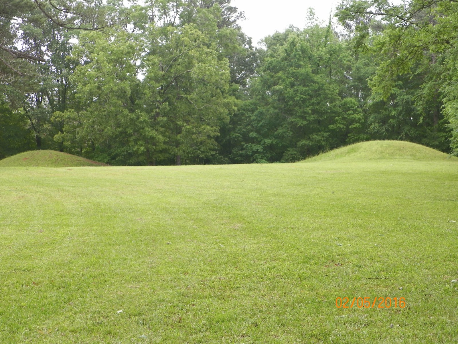
The largest of the mounds in this part of the
Mississippi Valley is Emerald Mound (mm 10), an 8-acre mound built between 1200
AD to 1730 AD. The mound is about 10
miles northeast of Natchez. It is the 2nd
largest mound of all known mounds; surpassing it is Monk’s Mound near Cahokia,
Illinois. Today, it measures 35 feet
high and its base measures 770 feet by 435 feet. On top of the main mound are two secondary
mounds, bringing the total height to 60 feet.
The mounds were built by hauling small baskets of soil and dumping the
earth on the mound. At long and tedious
task. There is a trail that allowed us
to access the top of the mound. As it is
a Federally protected site, you are warned by signage of the consequences of
disturbing the site. Many smaller mounds
were simply hauled away to fill low spots in the ground so that the land could
be easily farmed. The low spots were
often the holes where the soil had originally come from ages ago. Fortunately, we have many mounds that escaped
destruction.


Bear Creek Mound (mm 308), a later mound built between
1400 AD and 1600 AD. The information
sign indicates that the site had been inhabited for 8,000 years – but the mound
is of a more recent origin – so say the experts.


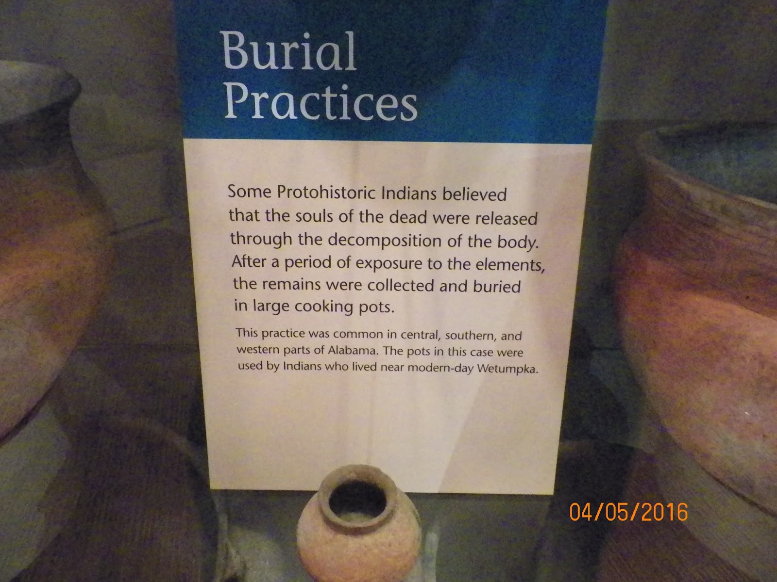
The Grand Village of the Natchez Peoples is located in Natchez. The site is preserved
by the State of Mississippi. They were
perhaps the last of the mound builders.
The site dates from about 700 AD and was still inhabited when the French
made contact in 1682 AD. The Natchez’s
downfall came when they attacked the French garrison at Fort Rosalie (which is
in Natchez) in 1729. The French were
really mad and eliminated these peoples and their village. It is believed that the few survivors took
refuge with other Indian tribes. This
brought the mound building era to a close.


There is a small museum on site, where further
information can be gleaned. Artifacts
recovered from the site are also on display.

It is not known what happened to the mound builders
and why the older mounds were abandoned.
The similarities to the Aztec stone buildings in central Mexico to the
dirt mounds seems more than coincidence to me.
Perhaps they migrated south?
During the most active use of the Natchez Trace, much
of the land in the southeastern USA was still in possession of what was known
as the Five Civilized Tribes of Native Americans. These tribes were the Cherokee, Chickasaw,
Choctaw, Creek and Seminole. Many of the
peoples of these tribes adopted the white man’s ways in terms of settlements,
agriculture, dress and even religion.
They believed all the treaty promises given to them by the federal
government. They did not suspect that it
was not adopting white man’s ways was not what was wanted. What was wanted was their land for
settlement. Truly a shameful part of USA
history.
As early as 1803, President Jefferson had predicted
that these peoples must be moved far away to the west. As the decades passed, settlement pressures
increased so much so that by 1830 the Indian Removal Act was passed by Congress
and signed by President Jackson.
However, in 1832, the Supreme Court said basically that this was not
legal. This ruling was ignored by
Jackson. In several waves, beginning in
1831, the greater part of the 5 tribes had been forced off their lands and were
relocated in Oklahoma. There was great
loss of life in the resistance to the move and in the move itself.
Our trip took us through the lands of the Cherokee,
Chickasaw and Choctaw. Near Tupelo, the
Chickasaw Capital was located along the Trace.
All that remains are a few signs and footing of their village buildings.


North of Jackson, Mississippi the Chickasaw boundary
with Choctaw lands is encountered along the Trace. All that remains of their presence is a
lonely sign along the Trace and in the place names of rivers and towns of the
area.


Cherokee lands were north of the Natchez Trace;
however, by happenstance, we stayed with a friend of Jim and Sandy’s who resides in
Vonore, Tennessee. In 1776, in the
Cherokee village of Tuskegee (present day Vonore) a remarkable man was born. We
know him as Sequoyah. He was the son of
a Virginia fur trader and the daughter of a Cherokee chief. He fought alongside of General (future
president) Andrew Jackson in the War of 1812.


During the war, he noted how the white man’s soldiers
could keep in touch with their families by writing letters home. Few, if any, of the Indians could read or
write in the white man’s language. After
returning home in 1814, he began the process of developing a system which he
reduced the thousands of Cherokee sounds into 85 symbols representing these
sounds.

In 1821, Sequoyah and his daughter introduced his
syllabary (not an alphabet) and within a few months, thousands of Cherokee
became literate. By 1825, the Bible had
been translated into Cherokee and by 1828 the “Cherokee Phoenix” newspaper
began publication. Sequoyah eventually
moved to Oklahoma and is believed to have died sometime between 1843 and 1845
during a trip to Mexico. Sequoyah’s
brilliance is represented by the quote:
“Never before, or since, in the history of the world has one person, not
literate in any language, perfected a system for reading and writing a
language.” The quote remained true until
Shong Lue Yang developed the Pahwah script for the Hmong language of Laos in
the late 1950’s.
During our travels, we visited several museums in
Tennessee, Mississippi and Alabama that gave further history of the early
peoples of these states. While Vicksburg
is chiefly noted for its role in the War Between the States, their museums also
feature the history of the Native Americans.


The Alabama history museum in Montgomery similarly has
a good portion of its exhibits focus on the early residents of the state.


3. Military historic sites.
We expected to visit several of the Civil War
battlefields along our trip’s route. We
found many of these sites and some other somewhat surprising sites of military
activity that was not of the Civil War era.
Twenty miles south of
Tupelo on the Trace, we find the general area where Hernando De Soto crossed
the future Trace in 1540. De Soto was a
Spanish explorer and conquistador who led the first European expedition deep
into the territory of the modern-day United States (Florida, Georgia, Alabama
and most likely Arkansas), and the first documented European to have crossed
the Mississippi. De Soto left Spain in
1520 and spent most of the rest of his years exploring and conquering in Costa
Rica. Nicaragua, Panama, Peru and southeastern North America.

Near to the Chickasaw village, noted in the previous
section, it is believed that DeSoto fought a battle with the Chickasaws, who
resisted his attempts to force them to be porters for his group. De Soto continued on his way and died of a
fever in 1542. It is believed that his
troops wrapped his body in a blanket and weighed it down with sand and then consigned
his remains to the Mississippi River.
The Spanish and French experiences in the Natchez area
have already been noted,
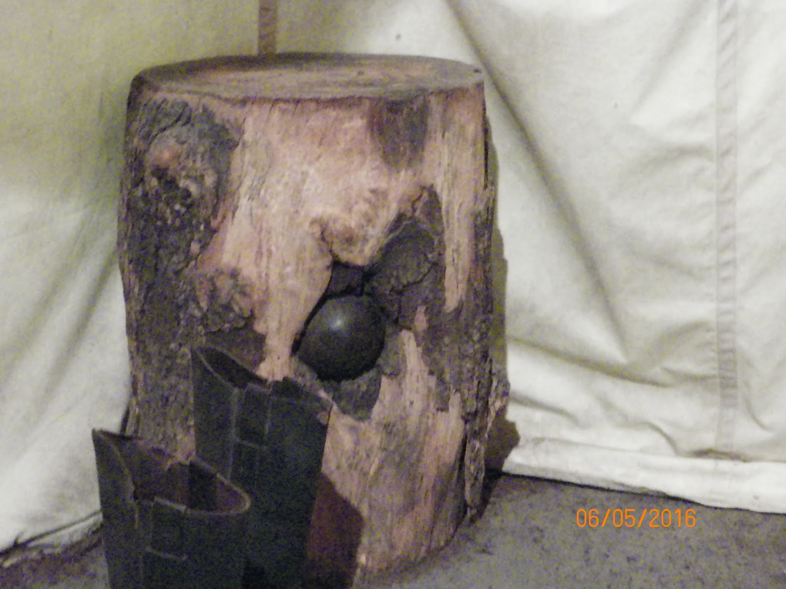
A big surprise was to find the restored Fort Loudoun
in Vonore, Tennessee.

This fort dates from the Seven Years War, known in
America as the French and Indian War. I
had no idea that battles from this long ago conflict had occurred in
Tennessee. The main thing we learned in
our history was about General Braddock’s defeat at Fort Duquesne and the battle
at the Plains of Abraham, just outside the walls of Quebec City (see slutigram on
the fall foliage trip in 2008).
During this conflict, Fort Loudoun was on territory
claimed by the State of South Carolina.
The various colonies had claims to western lands that extended all the
way to the Mississippi River. Several
claims conflicted between the colonies.
When the colonies became independent, this became a source of internal
conflict. All of the colonies
relinquished their claims with the adoption of the constitution in 1787.
Back to the fort . . .
To defend British claims to the Mississippi watershed,
a garrison from South Carolina marched into the future eastern Tennessee and
built the fort in 1756.


The Cherokee were allied with the British, but soon
the relationship broke down and the Cherokee attacked the fort in August,
1760. The British troops surrendered the
fort along with all of the armaments.

One of the actual canons has been found and was brought
back to the reconstructed fort.

The fort’s visitor center has several displays that give a
detailed narrative of the fort, its history and its reconstruction during the
1930s.


A monument to the War of 1812 is near the Natchez
Trace.

If you recall anything about this long ago conflict it is likely to be (1) during this war Francis Scott Key wrote the words to our National Anthem; (2) the British burned the White House, and (3) the Battle of New Orleans, USA’s greatest victory of that conflict was on January 8, 1815. Due to slow communications of that era, General Pakenham (British) and General Andrew Jackson (USA) were unaware that a peace treaty had been signed in Belgium on December 24, 1814. In today’s world of instantaneous communication, instead of killing each other, the battlefield would have been a place where the troops would have rejoiced and maybe even partied with the former enemy. Alas, more than 2,000 British troops, including 2 Generals were killed or wounded. American casualties were fewer than 20.

If you recall anything about this long ago conflict it is likely to be (1) during this war Francis Scott Key wrote the words to our National Anthem; (2) the British burned the White House, and (3) the Battle of New Orleans, USA’s greatest victory of that conflict was on January 8, 1815. Due to slow communications of that era, General Pakenham (British) and General Andrew Jackson (USA) were unaware that a peace treaty had been signed in Belgium on December 24, 1814. In today’s world of instantaneous communication, instead of killing each other, the battlefield would have been a place where the troops would have rejoiced and maybe even partied with the former enemy. Alas, more than 2,000 British troops, including 2 Generals were killed or wounded. American casualties were fewer than 20.
The Chalmette Battlefield is part of the Jean
Lafitte National Historic Park and is located on the eastern part of New
Orleans.


The reason for the one-sided casualty figures can
still be seen in the topography. The
British were attacking over an open field against entrenched forces of the USA,
who used cotton bales as protection. The
British could not get over the rampart and their bullets could not penetrate
the bales.


During our trip we encountered many sites of the
American Civil War, our most costly conflict in terms of loss of life than any war that
the USA has been engaged in. The causes
of the war were varied and can be traced back to the founding of the
nation. Two major results of the war
were the ending of the obnoxious practice of slavery in the “land of the free”
and the establishment once and for all that the dictates of the central
government were primary over the various states. One could spend a lifetime trying to visit
all of the sites of this war. In
Tennessee alone there are a few hundred sites of encounters. I’ll try to be chronological as best as I
can.
The first site visited never saw battle. From February 1861 to late May of the same
year the capitol of the confederacy was in Montgomery, Alabama. After the State of Virginia seceded from the
Union, the Capitol was moved to Richmond, Virginia. The First White House of the Confederacy was
the executive residence of Jefferson Davis and his family.


Surprisingly, the house was left standing during the
war and was fully restored in 1921. There are only seven stars on the flag, as that was the number of states that had seceded at that time. Eventually, 11 states withdrew from the union. Later flags have 11 stars.


Many of the personal items or Mr. and Mrs. Davis are
authentic.


Of course, we must give a nod to stamp collectors among
us and I did visit the First CSA (Confederate States of America) Post Office
headquarters in Montgomery.

A bit out of sequence here, but next to the White
House is the Museum of Alabama. It was
worth the visit and its admission cost is free.
There are exhibits about the state, its geology, American Indians, its
history from ancient times to modern day.
As far as military history, it had exhibits from the days of Spanish
occupation.

Buttons and uniforms of very early conflicts are on
display, as are many other items.


Ever been to Tangipahoa, Louisiana? Sounds like a Maori or other Polynesian name
to me. Camp Moore is located there
(www.campmoorela.com). This was a
training camp for soldiers during the Civil War. It was established in May of 1861 and
operated until Federal forces overran it in late 1864. After the war, the fort became overgrown with trees. Veterans of that conflict
came back at the turn of the 20th century and reclaimed and restored
the cemetery, where the remains of many of the 800 soldiers who died at the
camp are interred. Nearly all died from
disease or accidents.


The Camp has a small visitor center, staffed by
volunteers. Inside it are artifacts of
the war and the camp.


The main foci of the western theater of the War
Between the States (AKA the American Civil war) were twofold. Firstly, to deny the border states of
Missouri and Kentucky the opportunity to secede from the Union by stationing
troops in those states. Secondly, to
control the Mississippi River and several of its main tributaries, splitting
the Confederacy and denying it a means of transport and resupply of
provisions. The advent of the railroad
gave the Confederacy an ability to quickly move troops and artillery to where
ever enemy forces were massing. So,
besides control of the rivers, control railroad junctions also became an
objective.
A main railroad junction existed in Corinth, Mississippi.
By February of 1862, General U.S. Grant had
accomplished the first objective of removing Confederate forces from Kentucky
and Middle Tennessee. General Albert
Sidney Johnston had massed his troops at Corinth while General Grant began
landing his troops at Pittsburg Landing, Tennessee, just 22 miles north of
Corinth.

On April 6,
1862 the two forces met near the small country church at Shiloh.

Today that battlefield is known as Shiloh National
Military Park. However, Southerners call this the Battle of Pittsburg Landing. The visitor center has
the usual video and display that gives the history and importance of the
events that occurred during those two days of confrontation. Of the 66,000 Union and 44,700 Confederate
troops, over 23,000 were killed wounded or missing after two days of
engagement. That is nearly a 21%
casualty rate. Today we count our
casualties one by one; then they were counted in the thousands. Such is the waste and hell of war.


The area was heavily forested with some agricultural
fields. The battle was fought over a
large area as troops met in arms and then retreated back and forth. A paved road lets today’s tourist visit
several sites. Along the road are many
monuments and artillery pieces. The artillery pieces are from the war era, but
are not necessarily from the battle, as they were placed long after the war had
ended and there was no longer a use for these antiquated weapons of destruction.


The dead are honored differently. The Union dead were gathered and buried in a
central cemetery near the visitor center

An
all-too-common tombstone shows that the body interred below was
unidentified. Think of the anguish of
the families that were to never know if their son/brother/father/husband was
dead or alive or where or how they had died.

The Confederacy did not hold the field and their dead
are buried where they fell, often in a mass grave.


A rare event of warfare occurred when commanding
General Johnston was struck by a bullet that probably severed an artery in his
leg. He quickly bled to death. The site of his death is marked by a much
later constructed monument. President
Jefferson Davis and others had considered General Johnston to be his best
General.

Within one month Corinth was captured, thus denying an
important railroad junction to the South.
Our wanderings took us to Corinth right after our Shiloh visit. Corinth was a frontier town at the time of
the Civil War and was incorporated as a town in 1856. It had a railroad junction of an east-west
and north-south rail line and was thus a vital transport link that the Union
wished to sever.
A small visitor center has the usual flags, uniforms,
armaments, etc. and a pretty good video.
The fortifications of a part of the original defense of the town are on
this site.


After Shiloh, the town was overwhelmed with sick and
wounded southern casualties. On May 29th,
1862 Southern forces withdrew from Corinth, as they had not recovered from the
battle losses and the town was occupied by the Federal army. An attempt to retake the town occurred in
October of 1862, but failed. In January
1864, Federal forces abandoned the town, burning a greater part of the town on
their way out. While the federal forces
occupied Corinth thousands of “contraband” sought refuge there. “Contraband” was the word used to refer to
the slaves who were seeking freedom and protection from their former
masters. Many of these men subsequently
were organized into military units and fought with distinction during the
remainder of the conflict. Thus
disproving the common belief that the slaves could never make good
soldiers. A lesson that remained
unlearned until well into World War II.
Even at this late date (the 1940s), black troops mainly did labor
intense work, drove trucks or worked in military kitchens. Their prowess in conflict remained
unrecognized and was a source of ill feelings between black troops and the
military establishment.
By December of 1862, the Union advance into
Confederate territory had stalled on all fronts. On December 31st, 1862 through
January 2, 1863 the two armies battered each other near Murfreesboro, Tennessee
east of Nashville. The battle is known
as the Battle of Stones River. Another
battle, another visitor center and another cemetery.


The Union
forces were victorious, by the definition of victory at the end of the battle;
they held the field and the Confederates retreated. The casualties were: Union 13,249, Confederates 10,266. I’d say they both lost.
The remains of the earthen works defenses are
scattered throughout the town. Fortress
Rosecrans (the Union General) Brannan Redoubt is in pretty good shape and is on
a busy road in town.


Besides Sherman’s March to the Sea and the Burning of Atlanta, Georgia, the Vicksburg Campaign is the most widely known campaign in the Western Theater of the war. By late summer of 1862, only Vicksburg, Mississippi and Port Hudson, Louisiana blocked the Union’s complete control of the Mississippi River. Forces under General Grant crossed the Mississippi on April 30, 1863 and began a series of battles that culminated in the siege of Vicksburg.

One day after crossing the Mississippi River, Union forces routed the Confederates at Port Gibson.

The next encounter of any size was on May 12th
at the Battle of Raymond, which is on the way to Jackson, the State
capitol. A sign on the Natchez Trace
explains the battle and outcome.

A series of other battles led Grant's army to the fortifications at Vicksburg. Union forces made several attempts to seize the well-fortified town during the period after May 18, but were repulsed in every instance. A 6-week siege followed which ended on July 4, 1863 when General Pemberton surrendered. A few days later, the Confederates withdrew from Port Hudson. The Confederacy was now split down the middle and Grant had accomplished his goal. Soon after, he was given the command of the Eastern Theater of the War, as he fought and he won.
The town of Vicksburg and its battlefield are a must
see if you want to get a feel of what it was like to be under siege and to see
the lines of siege of the two armies.
First stop is, surprise! The visitor center of the battlefield.

On display are some unique items. Pictured from the battle is a cannonball embedded in a tree.
Portraits of the military commanders.


A 16-mile road winds along the lines of
engagement. Blue signs are for Union
units and Red for Confederate. Take your
time and stop at as many as you can to see where these brave souls fought and
died so long ago. We spent about a half day on the field.


The fortifications remain along with some artillery
pieces.


Long after the war, several states and other
organizations erected monuments to their fallen citizens. Most were erected before the last veteran of
that war passed away in 1959. In my
mind, the most impressive was the State of Illinois monument. Inside the monument the names of all the
fallen from that state appear on bronze plaques arranged by military unit.


Other state monuments include in this order Alabama,
Arkansas, Iowa, Kansas, Michigan, Mississippi, Missouri, Texas and Wisconsin (there may be other state memorials, but I have no photos of them).


A recently added monument is to the African American
soldiers who fell here.

Associated with Vicksburg, but not part of the siege
is the Ironclad riverboat “Cairo” which was sunk while clearing mines on the
Yazoo River below the bluffs of the town of Vicksburg in December of 1862. Just as recounted about the Steamboat Arabia
in the slutigram titled Happenings April through July 2008, the Cairo was
encased in river mud which protected it from deterioration for 102 years. In 1964, the boat was raised from the muck
and has been restored since then. The
last time we visited Vicksburg (2003) the restoration was not at the stage
that it is now. You can walk the decks
and peruse the items found on the boat in a small museum at the site. The iron and wood you see are originals not
replicas.


Right across the road from the boat is another
National Cemetery, where Union soldiers are buried. The Confederates were left where they fell
and then unceremoniously dumped in mass unmarked graves.

After spending hours touring, we stopped at a local bakery and each had a cinnamon roll, yummy.
They each weighed 8 pounds (nearly 4 kilos) and were the size of a loaf of bread.

Truthfully, we just looked at the rolls in wonder.
The City of Vicksburg and its citizens suffered
through the 6-week siege. They dug caves
in the soil and lived there during Union bombardments. Food disappeared, as did pets, rats and all
sorts of vegetation during this time.
The Old Courthouse Museum has several exhibits focused on the war and
several on other history of the city.
Jefferson Davis was a resident of this county and began his political
career here.


Four rail lines converged at Chattanooga, Tennessee. The small town of 2,500 lay alongside the Tennessee River, making it an
obvious target for the next Union advance.
In September of 1863, Confederate forces withdrew from Chattanooga. Union General Rosecrans believed that this
was going to be a retreat to Atlanta. He
was surprised on September 18-20 when he was attacked in strength at
Chickamauga, Georgia which is within a few miles of Chattanooga. A small visitor center graces this battleground
and a loop road takes you through the historic area with monuments and graves
of the fallen. The picture of the
Spencer Rifle has quite a bit of relevance to the latter years of this
conflict. Up until 1863, Confederate and
Union forces had similar infantry weapons.
You shot one shot, then reload powder, wadding and bullet and then use a
ramrod to pack it all in before shooting another round and then repeat the
process. The Spencer Rifle was
introduced to some units of Union infantry.
It was a game changer, as you loaded 7 cartridges, after each shot you
simply moved the lever near the trigger.
This ejected the spent cartridge and loaded another one. Besides that, you could load 7 new cartridges
in less time than it took to load one round in the old rifles. Firepower was changed from a few rounds a
minute to dozens per minute, giving the Union forces a great advantage.


However, even with the Spencer, the Union forces were
put on the run back into the town of Chattanooga. For the next two months, the Confederates
held these forces under siege, as they held the high ground at Lookout
Mountain, just on the other side of the river.
Here are views of Lookout Mountain taken from Chattanooga and of
Chattanooga from Lookout Mountain. The
river loops around Chattanooga at Moccasin Bend. Any ships using the river for movement of
troops or supplies would have been shot out of the water by the artillery. During November 23-25, General Grant ordered
his troops to take Lookout Mountain and assault the strength of the Confederate
forces under General Braxton Bragg at Missionary Ridge. The conflict at Lookout Mountain became known
as the battle above the clouds. I don’t
know how the Union forces did it, but they fought their way up the mountain and
dislodged the southerners and then due to a mix up, the southerners forgot to
join their lines on Missionary Ridge.
Fortuitously, Union forces attacked in the weakly defended part of the
ridge and ended up dividing the Confederate forces. Bragg was forced to withdraw to Georgia.


Along the Natchez Trace, north of Tupelo, Mississippi
(mm 269) in the quiet of the forest are the graves of 13 unknown Confederate
soldiers. They likely died from battle
wounds from the battle at Tupelo or from illness.


More soldiers died from illness during the war than in
battle. While it cannot be known for
certain, the historical consensus is summarized below.
The
Union armies had from 2,500,000 to 2,750,000 men. Their losses, by the best
estimates:
Battle deaths:
|
110,070
|
Disease, etc.:
|
250,152
|
Total
|
360,222
|
The Confederate strength, known less accurately because of missing records, was
from 750,000 to 1,250,000. Its estimated losses:
Battle deaths:
|
94,000
|
Disease, etc.:
|
164,000
|
Total
|
258,000
|
Tupelo is known for a more famous event than its Civil
War battle which took place on July 14-15, 1864. The Confederates tried and tried to push the
Federals out; but the Federal forces could not be dislodged. By mid 1864, the war's outcome could no longer
be in doubt, the South was near exhaustion and its resources to continue
resistance were running low.
Much of the battlefield has been lost to development
in this somewhat prosperous city. A
small park (maybe a small half-block in area) on a main highway in the city and
another outside of town can be visited.


The final battlefield of this war that we happened on
was in Selma, Alabama. In the closing
days of the Civil War in April 1865, the fortifications protecting Selma were
thinly defended and quickly fell to the invading Federal troops. The only thing we saw was this one lonely
marker to note what had occurred here. This was not the last battle of the war (see slutigram Winter 2013 in Texas Palmetto Ranch), but the last battlefield which we encountered on this trip.

What was perhaps as interesting was that nearby was
another marker that commemorated the visit of the French General Lafayette to
Selma in 1825, 50 years after he had come to America to fight alongside General
George Washington. The last Surviving
French General who served in the American Revolution toured 24 states (which
was all of them in 1825) from July 1824 to September of 1825.

The final conflict site (we have had too many wars)
that we visited was the National World War II Museum in New Orleans. Elaine and Sandy decided to wander the
streets of NOLA (aka New Orleans, Louisiana) while Jim and I spent the whole
day at this museum. The sign explains
why the museum is located here.


Exhibits and videos cover 3 very large buildings. Jim and I went our separate ways and met up
at closing time. The museum covers all
the theaters of conflict where USA forces were involved. Betio was a battle on a small Pacific Island
part of the Tarawa Atoll, which today is part of the nation of Kiribati.

Only recently, it was in the news in September 2016,
were the remains of several marines found from this long ago battle and were
brought home to the USA. Several found
their final rest in Arlington National Cemetery. While it has become somewhat popular these
days to question why Truman dropped the atomic bombs on Japan. Some say the Japanese were going to
surrender, others dispute this. The
Japanese soldier would never surrender, preferring death to dishonor. Even after the bombs leveled Hiroshima and
Nagasaki, the military urged the emperor to fight on. Fortunately, the emperor said no, he would
surrender, thus avoiding the bloodbath that was estimated to cost at least
1,000,000 allied casualties and uncountable Japanese deaths.

Let us move on to other things.
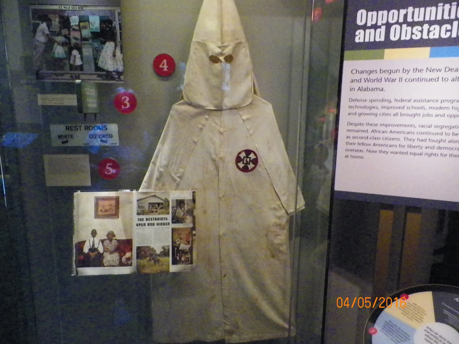
4. Civil Rights.
Sandy asked that we include some of the famous Civil
Rights places from the 1960s. We focused
on Selma and Montgomery, Alabama along with a few other places in Mississippi.
Selma, Alabama was the home of at least 15,000 voting
age African Americans in the 1950s.
Through various methods, local officials were denying their right to
vote. To evidence this, only 156 were
registered to vote in 1961. Such skewed
statistics were all too common during that era.
In February 1964, Martin Luther King was asked to come to Selma to draw
national attention to this injustice. He
was jailed and wrote his famous “Letter from a Selma Jail” which helped ignite
outrage all around the USA. It was
decided to march on the capitol at Montgomery beginning at Selma near the
Edmund Pettus Bridge, an apt symbol of the racism of this area at that
time. The bridge was named after a
Confederate Civil War General, later a Democrat US Senator and Grand Dragon of
the Alabama Ku Klux Klan.


The National Park Service has two Interpretive Centers
along the route of the March, one in Selma and one about halfway to
Montgomery. We visited both places and
the Alabama History Museum in Montgomery to learn more about those troubled
times.


In Montgomery we spent some time at the Civil Rights
Memorial and Interpretive Center. Maya
Lin designed the memorial. She is the
same person who designed the Vietnam Veterans Memorial in Washington, D.C. Ms Lin uses the power of names etched in
stone and flowing water in this monument.


Montgomery is the state capitol of Alabama and it was
from there that Governor George Wallace made his attempts to resist the
civil rights movement.

In his final years, Wallace recognized the error of
his ways and became a supporter of Civil Rights for all citizens, but he had
caused much damage before that time. He
was the longest serving governor of any state at the time. Iowa Governor Terry Branstad broke his record
in 2014 when he exceeded 16 years in that office. Wallace also ran for USA President on four
different elections. In 1968 he won over
10 million votes and took 46 electoral votes, all from former Confederate
states.
In Mississippi we found several places relevant to
African Americans and to the Civil Rights Movement.
I found the story of Port Gibson especially
interesting. Port Gibson is a county
seat and numbers less than 1,600 in population.
It is 80% Black and is poor. The
other 20% are mainly white and many trace their presence back to the cotton
plantation era before the Civil War.
Protests during the Civil Rights era of the 1960s against local business
practices (most businesses in town were owned by the 20% white) ended up with a
boycott of these businesses. The owners
of which fired many of their black employees.
Many of the businesses then failed.
Today, it is a quiet town, with many shuttered establishments, a
casualty of the movement. We never saw
another person during our time in Port Gibson, just empty streets and
buildings, not even a stray dog was seen.

Natchez has a Museum Of African American Art and
History, with artifacts and artwork on display. As far as I can find, the Mighty Fire was not a racially motivated event. It is believed to have started from a carelessly discarded match.


5. New Orleans.
Four days were spent in New Orleans. It was nice not to have to travel long
distances for a while. Besides the WW II
Museum, we took in many of the sites of NOLA.
The mighty Mississippi is only a short distance from where is enters the
Gulf of Mexico. Traveling on an old-time
steam riverboat is a fitting way to see the environs of NOLA. The “Natchez” takes half-day trips on the
river.


Part of the fare covers a lunch while underway. The menu included fish, hush puppies,
etc. A fair meal, but nothing to brag
about. As we travel downriver, many
barges, ships and riverboats for the tourists are seen.


Various NOLA buildings, factories and an old damaged wharf
are cruised by.


We are told that the level of a major flood in 1965
can be seen in the discolored brick of the building pictured. You may have to click on this pic to enlarge it to clearly see the water damage line.

Sampling the local cuisine tickled our taste
buds. The Café du Monde (Café of the
world) provides the famous beignet, a deep fried dough-ball smothered in
powdered sugar. The pastry comes in a
paper bag. If you save the sugar
remaining in the bag, it can take care of your baking needs for weeks. This is one of the must go to places in
NOLA. Every tour group drops its
busloads here, with the result of very long lines to get the pastry and coffee. Another bakery sells beignets, about
a block away, for half the price and without a waiting line. I suppose the tour guides get a cut of the
sales for directing their charges to the famous site.


Elaine’s brother recommended that we try a meal at
Pascal’s restaurant. It is located in a
quiet suburb of NOLA. All of us were
glad that we took his advice. I had some Creole shrimp in brine along with a potato dish – yummy. Our bibs were a necessity if you wanted to
keep your clothing dry.


The French Quarter has many buildings dating back to
the 1790’s. Some are kept up well,
others not so much.


The Basilica of St. Louis looks like the Disneyland Castle. Inside, it looks like a European Church. Its history goes back to Spanish ownership days.


Music can be found everywhere. Solo and groups perform on the streets and in many of the restaurants. With so much competition, the quality of play is good.

The famous playwright, Tennessee Williams once lived
in NOLA and wrote several well-known plays while resident.

The above-ground cemeteries of NOLA draw the tourists
in by the busload; in our case, by the carload. St. Louis #1 Cemetery is listed
on the National Registry of Historic Places.
Our tour guide is professional and doesn’t dwell on silly ghost stories,
rather she explained the history of the cemetery, why the bodies are above
ground, how many can be entombed in one mausoleum, etc. Why above ground? If you were to dig a hole, within a few
inches the water table would be struck, making for a very messy situation not
amenable to sanitation.


If you read the dates on this grave, you can see that
the first person in this tomb took up residency in 1884, followed by several
more, as recent as 1994. Doesn’t it get
a bit crowded in there? We are told that
the heat and humidity reduce the remains to bones in only a few years. The bones are pulverized and dropped down a
chute in the structure, making way for the next burial.
The xxx’s are supposed to indicate that this person
was a voodoo priest or priestess.

Some crypts are owned by a family or an organization,
while others are merely rented out until the body can be put down the chute.


Some other crypts have just sunk or are sinking into
the soil and are no longer usable.


A lot was learned and a lot of fun was had during
these four days in The Big Easy. Legend
has it that the earliest use of the Big Easy had to do with the fact that there were so many
ways for a good musician
to make a living in New Orleans. Another possible origin for the nickname is
connected to the relaxed attitude toward alcohol consumption that was found in
New Orleans, even during the days of
Prohibition. The relatively low cost of
living in New Orleans, in comparison to many
major US cities, has also been suggested as the origin of the nickname. Take your pick or just make up another
reason. Bye NOLA
6. Other interesting places.
Not everything that we did and saw can easily fit into
my 5 categories. I’ll end this narrative
by citing some of these.
Trying to get a flavor of the south, we avoided chain
restaurants and sampled some of the local dietary fare. I tried mustard greens, turnip greens and collard
greens and found that, with butter, they all were palatable. In Vonore, Tenn. we toured Benton Hams, a
smokehouse, and were given some of their delicious product.


Little Doohey’s in Starkville, Miss. provided us the
opportunity to feast on local BBQ dishes and various types of greens. It is definitely a locals place, but they are
welcoming to tourists. The BBQ trailer is impressive, to say the least.


The rocking Chair Café in Hohenwald, Tenn. gave us a
nice mid-day break.

The Tomato place in Natchez is mainly a seller of
fresh vegetables, but they also sell delicious sandwiches. I did not try the boiled peanuts, as I have
tried them before and found them wanting.

Also in Natchez, the Bellemont Shake Shop, an old time
drive-in restaurant offers some fantastic milk shakes. There is no inside seating and credit/debit
cards are an unknown.

Weidemann’s in Meridian, Miss. was established in 1870
and is the oldest restaurant still operating in the State. Great food and reasonable prices. Cloth tablecloths and cloth napkins – nary a
bit of plastic to be seen. That’s peanut
butter in the bucket. You are encouraged
to eat as much as you like of it.


Surprisingly, I actually lost a couple of pounds on
this trip in spite of all the great restaurants.
While passing through Columbus, Miss., we spotted the
home of the playwright Tennessee Williams, whose New Orleans apartment we
stumbled upon later on. The home
reflects his humble origins

Speaking of boyhood homes, Tupelo was the home of one
of my favorite performers, the King of Rock and Roll, Elvis Presley. His home makes Tennessee William’s home look
like a palace in comparison. More Elvis
stamps. As the entrance fee was
exorbitant, we passed on seeing the inside of the home.


You may have seen this postage stamp picturing Elvis last year. This was the 4th time he has appeared on an U.S. postage stamp. He has appeared on hundreds of foreign postage stamps; most notably by small African and Pacific Island nations as a means to earn revenue from stamp collectors and Elvis collectors.

Near Flora, Miss. roughly 36 Million years ago a log
jam resulted in many trees being buried, they became fossilized and are now
part of the Mississippi Petrified Forest.
This called for a detour from our main route. A walking trail takes you through the forest
where the petrified logs are in abundance.
They have long been buried in the loess soils, but as the soil is weathered
away by the wind and rain out pop the ancient logs. Besides the trail, a rock shop exhibits many
gemstones to include phosphorescent stones.
Well worth the detour.


Some like it hot, especially on Avery Island, Louisiana. This is the home of Tabasco Sauce, the
product of the McIlhenny Company since it’s founding in 1868, still owned and
operated by Edward McIlhenny’s descendants.
A self-guided tour takes one through the process of how the sauce is
produced. A very nice gift shop is on
the property (surprise, another gift shop) where various hot stuff can be
purchased. Additionally, a restaurant
enables you to use some on their product on your meal.


 |
| Add caption |


All this hot sauce is making me thirsty, so I’ll end
this very long slutigram of our Natchez Trace and other places trip. Hope you enjoyed it. If you made it this far, congratulations. If a typo or two or incorrect info is
contained herein, please let me know so that I can make corrections.